
A Scientist’s Surprising Optimism About Louisiana’s Coast
Earlier this summer I wrote a piece for Architectural Record about New Orleans and water. I talked to a number of experts in the course of reporting the story, among them Mark Schliefstein, hurricane reporter for the New Orleans Advocate | Times Picayune; architect David Waggonner; and Denise J. Reed, a professor of research at the University of New Orleans. Reed, a Cambridge-educated geographer who has lived in Louisiana for more than 30 years, calls her area of interest “coastal geomorphology,” a wonky way of describing the intersection of land and water, and how it specifically plays out on the Gulf Coast. She is former chief scientist at the Water Institute of the Gulf, located in Baton Rouge. I talked with Reed in late July, so clearly none of her remarks touched on Hurricane Ida. But I’m not sure this would have mattered anyway, as her perspective is a scientific one: She takes the long view and—somewhat surprisingly, at least to me, a professional skeptic—sees fact-based reasons for hope. Here’s an edited version of our lively conversation.
MCP: Martin C. Pedersen
DJR: Denise J. Reed
Where is New Orleans in relation to making the city the resilient place it needs to be as climate change presses upon us, sea level rises, and the land sinks?
I’ll touch on a couple of things. The levee system is in better shape than it’s ever been. But now it’s entering this phase where it needs to be reevaluated, in terms of what level of protection it will provide the city. There are a number of reasons for the reevaluation. One is, we think about storm surge risk somewhat differently than we did in the post-Katrina years. A lot of that was sparked by the work that was done immediately after the storm, moving away from the standard way of assessing flood risk to a more probabilistic approach. In order to do this probabilistic assessment, they create a digital set of synthetic storms, which collectively represent the characteristics of documented storms that have hit the area.
So we’re talking the 100-year storms, the 500-year storms, those assessments?
Yes, but a hundred-year storm is the wrong way to think about it, because the levee system is not designed for a hundred-year storm. It’s designed for hundred-year flood depths, which are different. The way that you come up with these flood depths is that you think about the characteristics of storms that influence how deep the water is at any given place. There are five characteristics that are generally considered to be important: central pressure, speed of forward movement, radius of maximum winds, track, and angle of approach. So it’s not the storm, per se, it’s the characteristics of the storm. Small and fast—even if it’s very intense—is quite different from large and slow.
The synthetic storms are created to represent the historical profile of storms, according to those characteristics. They’re used by the Army Corps, FEMA, and the state of Louisiana. They have been updated the last couple of years. They now include significantly more intense storms. All of that has changed our ability to characterize storms and results in a different way of thinking about flooding.
That’s one reason why the levee system has to be reevaluated. If it was deemed to provide a certain level of protection in previous storms, does it provide the same level, with our broader way of thinking about flooding? Then of course, other factors that have changed as well—land subsidence, for example. How is the system performing in light of that factor? So it’s currently under a reevaluation, and I believe it has to be recertified in 2023.
Who does that?
I think FEMA does it. There is also the issue about paying for the non-federal share of the initial rebuild. And, in a promising development, I recently saw the state set aside a large chunk of available surplus money to repay part of its bill to the federal government. The financial aspects of making the city resilient haven’t improved a whole lot. But there are promising recent developments involving upgrading the power system for the Sewage and Water Board, as well as getting on top of the maintenance of the drainage system. It’s an ongoing process, almost never-ending, but they’re starting to get a grasp around that. Outside the levees, in context of the coast, I would say that, in terms of the next 50 to 100 years, I sense some optimism that globally, we’re starting to do something about carbon emissions, not as much as what might be needed.
That’s an optimistic take.
A few years ago, 2017, there was a set of sea-level rise projections that came out for the U S. There was a low, an intermediate low, an intermediate high, and then an extreme high, which at that point was 2.5 meters of rise by 2100. I’m not sensing that anybody thinks that’s going to happen anymore—2.5 meters by the end of the century. I might be wrong, and science is obviously rapidly developing and constantly changing. It just takes a new revelation of understanding the balance sheet dynamics to change that. But look at south Florida: There was a Florida climate compact, and it published a strong document, where they talked about what kind of sea-level rise scenarios should be used for different infrastructure planning in south Florida. And they didn’t recommend using the extreme height for anything.
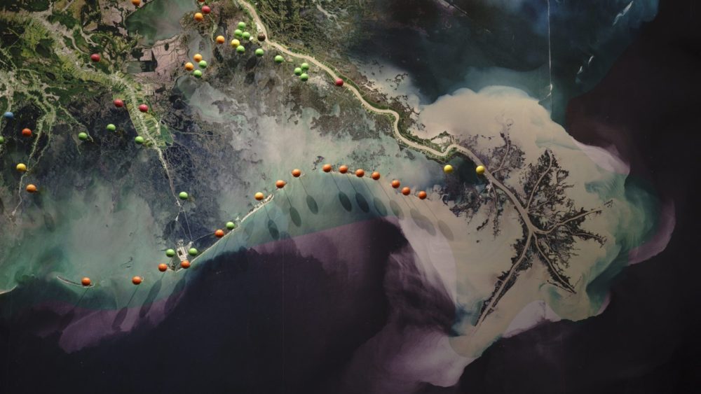
A map of land building projects, levees, floodgates, and other coastal habitat improvements in Louisiana. Image by Drew Angerer via Grist.
But that’s pretty dangerous, right?
That’s your opinion. And you’re a writer for Architectural Digest.
Architectural Record.
I think I might trust the scientists. I’m just telling you where I think we are. If you want to second guess it, that’s totally up to you. It’s important to get messages like that out, if they have some credibility, because the idea that things are just getting worse and worse and worse and worse and worse and worse is not a message that actually helps people act.
As far as coastal work is concerned, the funding from all things related to Deepwater Horizon—the criminal settlements, the NRDA settlement, civil payments—all the different sources of money allows the state of Louisiana to feel like it’s on the cusp of building land restoration projects at a scale, which we’ve dreamed of for a long time. So that is optimistic. We have the money potentially to build some really big projects. And we have the science aligning around that. There’s still a certain amount of political will that needs to get behind that. Unfortunately, we see elected officials in our state not all speaking with the same voice, which is disheartening. The public could well be very confused by that. Still, scientifically, we’ve made huge strides in developing tools and analyses to move those things along.
Now is the state’s approach to coastal restoration subject to political tampering? If you get a governor that’s less sympathetic to diversions, who might even deny climate change outright, where does that put the master plan?
The act, which calls for the state to periodically produce a coastal master plan, has a very interesting aspect to it. The plan has to be approved by the legislature each time it’s updated, every six years. The next vote is 2023. It goes to the legislature for an up or down vote. If they vote the new plan down, the 2017 plan stays in place.
That was smart.
Yes, exactly. To some extent, there’s a bit of insulation to the coastal master plan process. But remember, the coastal master plan doesn’t build projects. It lays out a path forward, identifies the projects and locations that they want to work on. Although it’s less subject to shenanigans, nothing is absolutely set in stone. So there’s some cause for optimism around restoration, but there’s still a huge amount that we need to do. There’s not any progress on rethinking Mississippi River management, in a big way.
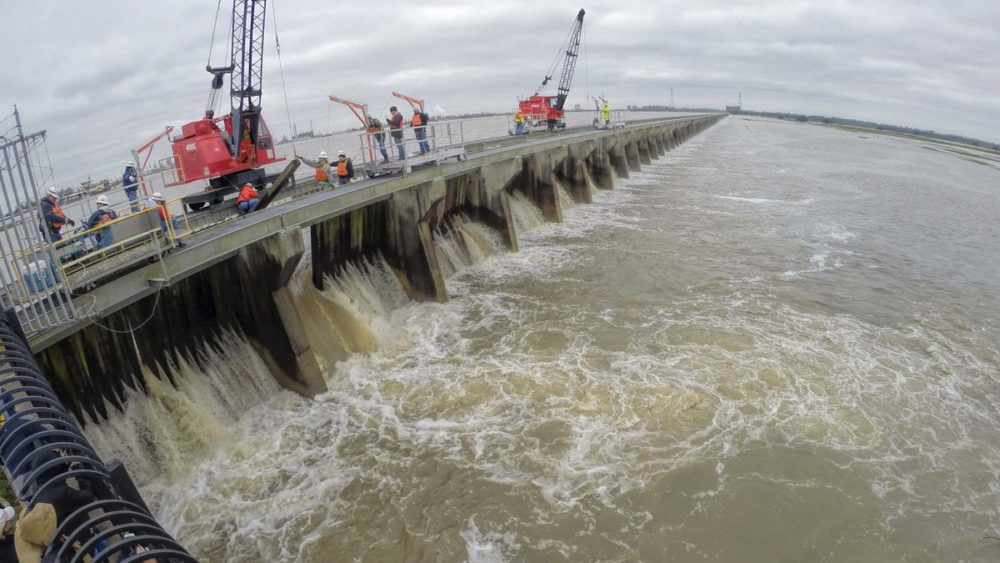
The Army Corps of Engineers operates the Bonnet Carre Spillway, in St. Charles Parish, as a giant relief valve to prevent flooding downstream in metropolitan New Orleans. Photo by John Snell.
What would that mean, rethinking river management? Would it mean essentially more diversions, in more places?
It could mean that, but it could mean lots of other things. It could mean rethinking the use of something like the Bonnet Carre Spillway. It could mean asking why we are still maintaining the Birdsfoot Delta in order to have Southwest Pass. There’s been a number of calls, certainly since Katrina, for a large rethink of river management. But it’s difficult, a big lift, because of the federal responsibility, because of the way the Corps’ organization is structured, project by project, through authorized appropriations. On balance, I think we’ve got some good developments. We’ve also obviously still got a long way. The idea of New Orleans as a Resilient City is not something that you’re going to complete. It’s going to be an ongoing effort. You celebrate progress in order to keep going.
You’re more optimistic than a few other people that I’ve talked to.
Well, I couldn’t get up every morning and work on this if I were really pessimistic about it. I just don’t find it useful to be totally pessimistic about it. Otherwise, why would you work on these projects if you don’t think that they’re going to make a difference?
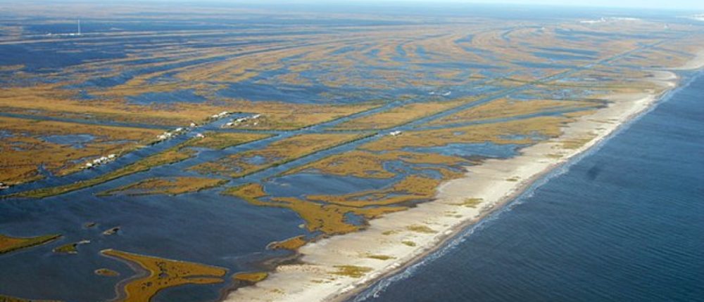
Featured image via the U.S. Geological Survey.