
A Missing Line in the Housing Conversation
Right now, every resident of Toronto is paying for 31 square meters of pavement. It costs the city $132 CAD annually, per person, to keep that pavement resurfaced, reconstructed, and maintained, every year, for as long as that street exists. None of that money pays for anything new; it’s simply the cost of standing still.
Cities across North America are struggling with an important question: How do we pay for growth? Development charges, land value capture, public-private partnerships, new property tax tiers—every council chamber has some version of this debate underway. Few of them are asking the fundamental questions sitting beneath all of it: What are we spending that money on, and does it need to be this expensive in the first place? Our roads and rights-of-way are the biggest single line item in that budget, and yet they are rarely questioned as cost drivers. Funding debates focus on how to pay for roads, not on how much road we are building.
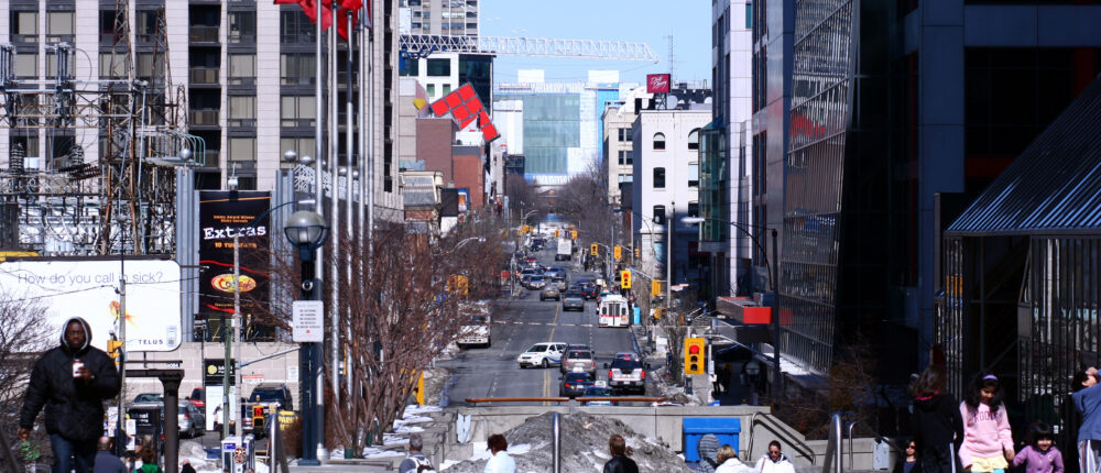
At the scale of a whole city, that line item is enormous. Toronto spends roughly $400 million a year building, resurfacing, or reconstructing 400 hectares of streets, sidewalks, and bike lanes. That pavement accounts for 15% of the city’s land area. It is, by a wide margin, the single largest piece of real estate any municipality owns and operates, and yet it barely features in the conversation about how to pay for growth, or where to put new housing.
Most of what North American cities are maintaining today—our four-lane arterials, boulevards, and oversized suburban cul-de-sacs with generous margins on every side—were built largely during a specific period: the rapid, car-first expansion of the 1960s and ’70s, when planners assumed car ownership would keep climbing indefinitely and treated land as though it cost nothing. Those assumptions are written into the standards that still govern how a street gets designed today: level-of-service targets calibrated to peak car volumes, minimum lane widths borrowed from highway design, turning radii sized for the largest vehicle a street might ever see. Decades after the conditions that produced them have changed, our standards have not, and as a result we continue to hand over vast amounts of land and financial resources to meet them.
After years of use, the bill to renew and repair all of this infrastructure has come due. Nearly 40% of Canada’s roads and bridges are rated fair, poor, or very poor, and roughly 80% are already more than 20 years old. South of the border, the American Society of Civil Engineers gave U.S. roads a D+ in its 2025 Infrastructure Report Card, finding that 39% of major roads remain in poor or mediocre condition and estimating a $684 billion funding gap over the next decade just to bring the network into a state of good repair. Cities are being asked to build their way out of a housing shortage while using the same balance sheet that cannot cover the repair bill on what we have already built.
Urban planner Charles Marohn and the Strong Towns movement have spent more than a decade explaining how that balance sheet got so strained. Postwar suburban expansion functioned like a Ponzi scheme: each new subdivision generated a burst of upfront tax revenue and development fees while quietly obligating the municipality to decades of maintenance that low-density development, with so little taxable value per metre of road and pipe, could never generate enough revenue to cover. As Marohn has noted, over a full life cycle, a city frequently collects just a dime or two of revenue for every dollar of long-term liability it takes on. Cities have absorbed that gap for decades by continuing to grow outward, using new development to service the debts of the old. That is the same dynamic underneath today’s funding debates, just with updated language. New development charges and land value tools are still, in effect, asking new housing to cover the cost of infrastructure that was oversized from the start. Every Ponzi scheme eventually reaches the point where there is no new money left to recruit, and cities are at that point now. The choice left is not how to find the next round of investors, it is whether to stop taking on liabilities they cannot afford to keep.
That is what a sufficiency lens on rights-of-way offers: not a new way to pay for the roads we have built, but a way to need less of them. Every meter of road coming up for resurfacing or reconstruction, every meter being designed for a new site, is a chance to ask, Does this street need to be this wide? Getting that question right pays out on the fronts cities are already struggling with. It supports housing supply, because land currently locked up in oversized rights-of-way can carry homes instead. It protects land, because a narrower footprint leaves more of a site as usable, absorbent, and shade providing green space rather than pavement. And it reduces costs and carbon, because less asphalt and concrete means less to manufacture, pave, and repave. Three problems cities are separately trying to solve, mostly with new revenue tools, turn out to share one lever.
Our firm tested that lever directly. As part of a rights-of-way study by Ha/f Climate Design undertaken for Northcrest Developments at Downsview, we looked at what actually happens when a plan applies a sufficiency lens to its streets rather than defaulting to the standard cross sections. One of the masterplan’s north-south avenues was reduced from 33 meters to 24, and its east-west ladder of short streets from 27 meters down to 17.4, as illustrated in the image below. In each case, this reduction was made possible by removing a travel lane, trimming pedestrian zones modestly, and asking whether a dedicated turning lane and a fully buffered cycle track were genuinely needed on every street, rather than only the busiest ones.
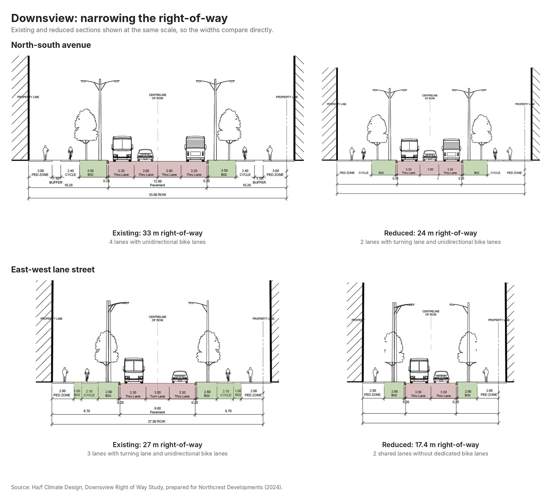
The results show all three benefits landing together. The study area’s reduced right-of-way scenario supported 145 additional homes, roughly 4% more housing, without adding a single story. Greenspace rose by 10%, most of it added internally to each block, where it can double as stormwater management and playspace directly beside buildings rather than relying entirely on infrastructure elsewhere in the city. Embodied carbon per unit dropped slightly even as density rose. Critically, road area fell by 35%, leaving far less pavement for the city to build, plow, and resurface in perpetuity. Simple reductions in width led to more housing, more land protected, more resiliency, and less carbon, all from the same decision to stop building the road wider than the street actually needed to be.
Working alongside O2 Landscape Architects on the same site, we pushed the sufficiency question further: not just how much width a street needs, but where that width could deliver the greatest value. Downsview’s avenues sit at a steep angle off of Toronto’s primary north-south grid, which means one side of nearly every street receives sun and wind for most of the day while the other sits largely in shade. An asymmetrical approach moves width to where people actually are, trimming the sidewalk on the exposed or underused side and using that space to widen the sidewalk, add patio seating, or consolidate planting on the side people are drawn to. It is the same land and same paved area, rearranged to do more.
None of this becomes the default while the standards generating a right-of-way stay fixed. Level-of-service assumptions calibrated for peak car volumes, minimum lane widths inherited from highway design, turning radii sized for the largest possible vehicle, parking minimums that assume every trip is a car trip—these are the quiet defaults that make an oversized right-of-way the path of least resistance for any engineer or planner, on a new site or an existing street, whatever their intentions. Changing them does not require reinventing how a city is governed. Instead, it requires taking a sufficiency test, starting with Does this street need to be this wide? This ought to be the first question when a street comes up for renewal or a new one gets designed, rather than a variance that has to be justified street by street, project by project.
Ha/f is currently working with the City of Toronto on exactly this question, looking at where the city’s standards can change to reduce what the city has to build and maintain in perpetuity while supporting its ambitious housing targets and climate commitments. Alongside DTAH and Arup, we are reviewing the city’s design and engineering standards for its public realm, streets, sidewalks, and parks, to understand how future changes could lower cost and carbon while improving resilience. Toronto’s recently published Thermal Comfort Guidelines point to asymmetrical street cross-sections as a preferred response to sun and wind exposure, not a niche design gesture reserved for a single development.
Cities do not need a new funding tool to solve the puzzle sitting at the center of the housing and infrastructure conversation. They need to look at the land they already own and ask what more it could do, and how it could cost less. As this generation of infrastructure comes due for renewal, that question, not the next revenue mechanism, is the one worth putting first.
Featured image via Wikipedia.